Romania is a country situated in the Northern Hemisphere, on the Continent Europe. Its treitory is crossed b the Parallel 45 N and Meridian 25 E. This position placed is half-way between the Equator and the North Pole, entirely in the temperate zone. The climate is moderate continental, whit fairly mild winters and hot sumers.
The terytory of Romania extends between 4grades 37'59" latidtude (525 km), from 48grades 15' 06" (Horodistea) to 43graes 37'07"(zimnicea),and 9grades25'40" longitude (743 km), from 20grades 15'40" (Beba Veche) to 29grades41'24" (sulina).
The country has a favourable geographical position. It lies in the Southeastern part of Central Europe, an area of contact between Eastern Europe and the Balkan Peninsula, at the crossroads of the maor European highways.
The distance separating the centre of Romania from the extreme continental points is the following : 2800 km from Nord Capp (North Cape); and 1050 km from Alkra Tainaon (Matapan Cape); 2750 km from Capo Finisterre, and 2600 km from the Ural Mts., the eastern extremity of Europe. Its present boundaries encompass the best developed of the Carpathian chain and the Lower Basin of the Danube down to the western coast of the Black Sea. The country's frontier lines total 3185 km, whit runing waters representing 58.4%, conventional land 32.6% and sea waters up to the international maritime limit in the Black Sea, 9%.
Romania covars an area of 238391 sq km, that is, 4.8% of Europe AndHas a population of 22 730 622 july 1, 1994. It is, there fore, a medium-sized state, yet the largest Southeastern Europe.
Beacause the sinuous Carpathian mountain range is an obstacle to the circulation of masses of air, the territory of this country forms o knot of climatic influences: Oceanic (from the West), Contnental (from the East) and Mediterranean (from the south). This, in turn, shapes the distribution of water and of vegetation. At the same time, the Carpathians cause a change of latitudinal zonalyty, inducing the vertical variability of physico-geographical conditions.
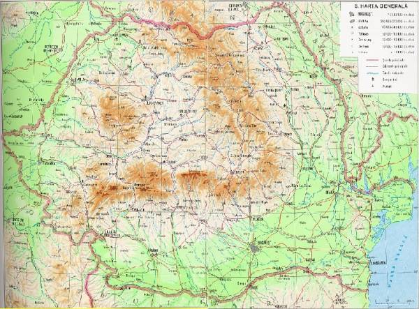
Although there is a huge diversity of natural conditions, resources, and functionalities, Romania's territory is remarkably unitary as a whole. There is an amphitheatre-like layout of mountains ,hils and plains, whit the Carpathian Arch standing in the middle- a natural stronghold, indeed.
the relief presents three distinct steps, from the 2544 m- high Moldoveanu peak in the Fagaras mts. down to Black Sea shore; the central bastion of the Carpathien Arch, whit altitudes between 800m and 2500m, covers 28%of the romanian territory; The mountain-surrounded TransylvanianTabelland, togetherwhit the hills and the plateaus outside the Carpathiens, streaches, as a rule, from 200m to 800m alt. and covers 42% of the territory; the plains, situated in the South and the west of the country, representover 30% of its surface-area and reach altitudes below 200m.
The configuration and the concentrical arrangement of the relief are the work of a paleo-geographical evolution. The formation of the Carpathian range, thatbegan in the Midde Cretaceous as part of the Alpine orogenesis, was of outstanding importance, it being basically involved in the emergence of the marginal depressions periodically flooded by sea, brackish and lacustrine waters. These depresions would receve and deposit the material eroded from the mountains.
the Carpathians themselves are not imprenetrable. On the contrary, they are cut by numerous depressions and wide longitudinalor transversal valleyse.g. the Olt, Jiu, Mures, Somes and the Danube, witch, from very ancient times, have emerged as favourable setelment locations. The source area of some of these valleys is crossed by passageways, most of them at heights of 800-1200m They represent routes of communication between Transylvania and the extra-Carpathian regions. The Rounded, step like summites, quite flat in some places, have long experienced circulation through traditional sheep-flock transhumance. Alpine landforms, preserving traces of former glaciers, ocur anly above 2000m alt., especially in the South Carpathians. These insular occurrences cover small arreas.
The stepwise arrangement of the relief whit summites over 2500m , has engendered distinct climate soil and vegetation belts and distinct geographical land sxapes. At altitudes over 1700-1800m, the weather is cold, average annual temperatures running between 2grades and -2grades, winds are high and precipitations exceed 1200 mm/year.It is the realm of alpine and sub-alpine meadows, of summer grazing and mountaineering. Next come the mountains and the hills. The weather being milder here, the land is covered by coniferous and leafy forests(whit beach prevailing; Romania is theeastern extremity of its distribution).At lower altitudes, plains and hillocks are prominent. mean annual temperatures range from 9 to 11 grades C and there are fewer precipitations (500-700 mm/year).It is the domain of oak forests.In the plains of Baragan, southern Moldavia and Dobrogea, as well as in the Western Romania Plain, fields and woods are interespresed whit steppe mesdows. This last relief step is a predominantly cereal crop area; hillocks are renowedalso for the groth of vine, Romania representing the northren groth limit of this culture.
Some 98 per cent of Romania's watercourses,except for those of East Dobrogea witch run straight into the sea trough coastal limans, are drained by the Danube. Rivers in Transylvania (but not the Olt), Maramures and Crisana flow westward, into yhe Tisa. All the Others, flowing from North To South, North_west to South-East (the Jiu, Olt, Arges, Siret and Prut) run into the Danube. After penetrating the Carpathian mts. trought the defiles of Cazane and the Iron Gates, the Danube divides the Romanian Plain from the Prebalkan Platform. Lowlyng areas include the Ialomita and the Braila swamps(drained today and used as cropland) and the Danube Delta, a biosphere reserve. The Danube, a navigable waterway, is expected to attract a grater share of European trafic due to The Danube- Rhine and Danube- Black Sea canals. These canals from dirct link between the ports of Rotterdam in Holland and Constanta in Romania. The Braia-Sulina Sector has long been navigable. Freight cargo has been crossing it since 1870 and it has all the facilities needed by high-tonnage vessels.
in the past few decades, the numerous reservoir lakes built in Romania have been a source of electric power and industrial water suply. The major hydropower stations are located on the Danube (At iron Gate and at Ostrovu Mare) and on the Carpathian rivers: Bistrita, Lotru, Arges, etc.
The Administrative organisation of the territory has seen some changes in the course of time, conected whit socio-economic and political developments.
the basic administrative-territorial unit is the county, judet in Romanian- ancient administrative form in these parts. The term comes from the Latin judicium (the centre of judicature).Today, the territory of Romania is Divided into 41 counties and the municipality of Bucharest, the country's capital-city. The basic administrative county units are the town and the commune formed of one or several vilages, depending on their economic developement and acces rutes. The villages are the oldest form of organisationin this country, the core of the entiresettelment network witch icludes now 262 towns (of witch 80 are municipia) and 2686 communes whit more then 13000 vilages.
Romania's geographical position and natrural enviroment being very favourabile, people used to settle here from very ancient times. Rural settelments cover the whole territory, clustering in the hills and the plains, but freqently streching up to the mountain areas' too, where they agglomerate along the valleys and in the intramontainous depresions. Many of the old towns have grown into complex.
A ferly dense road and rail network ensure economic links between settelments. It consists of a few concentrical rings witch follow the the configuration of the relief and are conected by numerous ramifications, converging all toward the heart of the country. Part of the network is connected to big continental trafic lines ilnking Western And Eastern Europe to the Balkan Peninsula. Maritime traffic trough the prots of Constanta, Galati and Braila, river traffic along the Danube and air traffic connect Romania to the principal economic routes of Europe and the world.
Encompassed in the Carpathian- Danubian- Pontic space, the territory of Romania has been a meeting place for the world's greatest civilizations. Its geographical location would explain the economic and political interest vested here through the centuries. Today, with geostrategical advantages proving equaly attractive for the East and the West of the continent, Romania is viewed as an important bridge that bridge that links the Balkan and the Middle East countries to Central Europe.

General Description Of Romania
General Map Of Romania